Peyto Lake is one of the most photographed lakes in the Canadian Rockies — a strikingly turquoise, wolf-head-shaped lake viewed from a dramatic cliff-top viewpoint on the Icefields Parkway. It's a must-stop for anyone driving between Banff and Jasper, and even worth a day trip on its own. Here's everything you need to know about visiting this turquoise gem.
Where Is Peyto Lake?
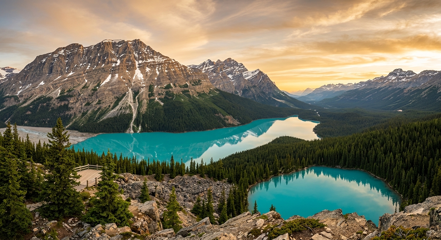
Peyto Lake (pronounced PEE-toe) is located along the Icefields Parkway (Highway 93 North), approximately 40 km north of the Highway 1 junction near Lake Louise. It sits at 1,860 metres elevation in the Waputik Range, fed by glacial melt from the Peyto Glacier and surrounding ice fields. The lake is named after Bill Peyto, a famous early mountain guide and park warden.
Getting to the Viewpoint
From the Bow Summit parking lot (the highest point on the Icefields Parkway at 2,088m), a paved, accessible pathway leads approximately 500 metres to the Peyto Lake viewpoint platform. The walk takes about 10-15 minutes each way. The platform is wheelchair accessible and offers the classic elevated view down to the lake.
Parks Canada recently upgraded the trail and viewing platform to improve accessibility and manage the large number of visitors. The new pathway is wider, smoother, and has interpretive signage along the route.
Why Is Peyto Lake So Blue?
Peyto Lake's vivid turquoise colour comes from glacial rock flour — ultra-fine particles of rock ground by the Peyto Glacier and carried into the lake by meltwater. These particles are so tiny they remain suspended in the water and refract sunlight, creating the intense blue-green colour. The colour is most vivid in mid-summer (July-August) when glacial melt is at its peak.
Best Time to Visit
- July-August: The most vivid turquoise colour as glacial melt peaks. Busiest period — arrive before 10am for easier parking
- September: Slightly less vivid colour but fewer crowds and golden larch trees on the surrounding slopes
- June: Early season — the lake may still be partially frozen or just beginning to turn colour
- Winter: The viewpoint trail may be accessible by snowshoe, but the lake is frozen and the colour is gone
The viewpoint faces roughly north, so direct sunlight illuminates the lake best from mid-morning to early afternoon. Overcast days can actually produce excellent photographs — the clouds diffuse the light evenly and the turquoise colour stands out against grey skies.
Hiking Beyond the Viewpoint
Bow Summit Lookout
For a more adventurous experience, continue past the main viewpoint on the Bow Summit trail, which climbs to a higher vantage point with even more dramatic views. The trail gains an additional 95 metres over 2 km and is well-marked. The higher viewpoint offers a broader perspective of Peyto Lake and the surrounding peaks. Budget an additional 1-1.5 hours round trip.
Peyto Lake Lakeshore
It is possible to hike down to the lakeshore via the old unmaintained trail, but Parks Canada discourages this due to erosion and environmental sensitivity. Please stay on the designated trails to protect this fragile alpine environment.
Practical Tips
- Parking: The Bow Summit parking lot is popular and fills quickly in summer. Arrive before 10am or after 3pm for the best chance at a spot
- Time needed: 30-45 minutes for the viewpoint; 2 hours if you hike the Bow Summit trail
- What to bring: Camera (wide-angle lens ideal), warm layers (it's windy and cool at 2,088m), and water
- Accessibility: The main viewpoint trail is paved and wheelchair accessible
- Park pass: Required. The Icefields Parkway is within Banff National Park
- No facilities: There are no washrooms, water, or food at Bow Summit. Use facilities in Lake Louise or at Saskatchewan River Crossing
Combining with Other Stops
Peyto Lake is best visited as part of an Icefields Parkway drive. Combine it with nearby stops including Bow Lake (4 km south — incredible turquoise reflections), Mistaya Canyon (32 km north), and the Columbia Icefield (87 km north).
Enjoyed this guide? Get weekly Banff tips.